Having now finished a round of Munros, I am enjoying ticking off some previously visited Munros again. I have been choosing Munros that I have only a vague memory of walking, as well as some classic Munro bagging routes.
Recently, I did a run-hike of the South Glen Shiel Ridge. It’s a route featured in the Running Adventures in Scotland book. See my review of the book.
It was in 2014, that I first traversed this ridge, which takes in no fewer than seven Munros. In the intervening years, I have become far more confident and experienced in the Scottish mountains and what seemed like a huge and tiring undertaking eight years ago, turned out to be much more manageable and far less daunting this time.
This is not to say that the South Glen Shiel Ridge is an easy route. The distance extends to 28km and the total elevation is almost 2000m. If you then add the section back along the A87 road from the end of the ridge to the start, it’s another 11km or so on foot or by bike, plus a further 200m of elevation.

Note: Most people choose to avoid the road section. You could double up with a friend and leave a vehicle at each end of the hiking route, or leave a bike at one end for your return. There is a bus service, too, and I would advise you use the bus at the start of the day, rather than hoping you will make it to the end to catch a fairly infrequent bus service. Or, you can thumb a lift, which is what many people do because it’s a well-known ridge walk and, therefore, there are likely to be plenty of people offering a pick up.


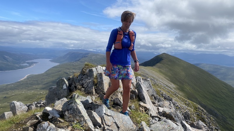
Run-hike of South Glen Shiel Ridge
It was my friend Izzie who suggested an outing to complete the full ridge. We headed across to Kintail in north-west Scotland last Thursday after a long spell of good weather. Although the forecast didn’t look great, it also wasn’t woeful. So, we took a calculated chance.
We carried fairly lightweight fast-hiking packs, making sure we had waterproof jackets, waterproof trousers, a spare baselayer, an insulated jacket, gloves, headwear, sunglasses, emergency bivvy bag, map and compass, food and water.
We considered using running poles but, in the end, we forgot to take them when we left the car. We were fine without them.
Our route choice was east to west, because this would mean we had less overall ascent (around 200m less) compared to going in the opposite direction.
My memories of the route were that it was a long walk to reach the start of the climb to the first Munro, then a long and hard slog to the first Munro, Creag a’ Mhaim, followed by an exhausting day to reach all seven Munros. I also recalled a very long and arduous descent to return to the roadside.
My second outing felt very different. Izzie and I ran most of the first section along a track, starting at the western end of Loch Cluanie. The track is around 6km long and while it heads further east to reach the base of the Munro, this approach has the bonus of being more gently uphill. The alternative would be to climb directly uphill on rough terrain without an obvious path.
By the time we started the steeper climb to the summit of Creag a’ Mhaim, we were at 400m elevation.

This climb was a mix of walking fast and some running. We aimed to run the flats and downs, while fast-hiking the ups. When one of us wanted a breather, we both stopped and enjoyed the scenery.
I felt as if the first summit at 947m elevation came quite easily and, once on the ridge, we could see many more summits spreading out ahead of us. The weather was far better than expected and although cloud drifted around the higher tops, we still had a fairly clear sight of the landscape.
The Kintail area is stunning with numerous steep-sided mountains plunging down towards magnificent glens and spectacular lochs. Wherever we looked, Izzie and I were treated to a fabulous vista.

On to Munro 2 and 3
We stopped only for a short time to take photos and have a bite to eat on Creag a’ Mhaim before descending and then ascending again to the top of Druim Shionnach.
Again, it seemed that the summit, at 987m elevation, arrived swiftly. Looking at the map, it is hard to believe all these Munros could be so close to each other but we didn’t complain. When you have seven summits to complete in a day, it’s very satisfying to be able to tick off the first few with relative ease.
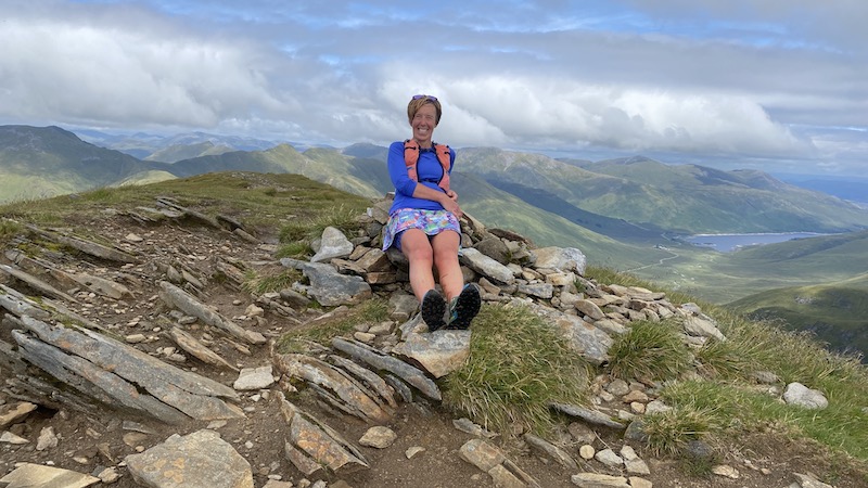
Izzie and I had decided we were not going to be in any particular hurry although we enjoyed many sections of running.
At times, the path and gradient were perfect for a gently paced run, while at other times the path became too rocky or gnarly for anything other than a walk, or else the gradient was too steep to run up.

The third Munro, Aonach Air Chrith, is the tallest of the seven on the ridge at 1021m. Again the descent and ascent felt relatively easy in comparison to many other multiple Munro outings.
We enjoyed plenty of high-level views, however as we reached Aonach Air Chrith we were surrounded by cloud. This turned out to be the only Munro on which we didn’t have a view.
I have often said that I like a mountain day with a mix of cloud and blue sky because it offers far more drama and atmosphere than a bluebird only day. I love the way the cloud suddenly moves on or opens up to reveal the drama of the landscape.


South Glen Shiel Ridge: Munros 4, 5 and 6
In good weather, it is relatively easy to follow the route all the way along the South Glen Shiel Ridge. Even in cloud, so long as you can see a few metres ahead, it is straightforward to navigate a safe route.
It’s still important to have a map and compass with you and to have the back up of a route uploaded on to an app on your smartphone. We had the added bonus of the route to follow on Izzie’s watch. She was able to keep me posted about the distance and elevation still to complete. (Towards the end, we found the details were a little shy on height and distance but it still provided a good guide.)
We were really happy with the progress we were making, although as we headed on to Munro four, Maol Chinn-dearg, I could feel the effects of the accumulated effort in my legs.


For the most part, although following a route along a ridge, it’s rarely too airy. There are, however, some narrower sections where the mountainside slopes off steeply either side and, at times, we needed to ascend and descend some short, steep rocky sections that required a bit of a head for heights. I am not comfortable with narrow ridges but I wasn’t daunted by any part of this ridge.

On Munro four, Maol Chinn-dearg, we met two people. They were carrying much heavier packs and told us they had ascended the first Munro the night before, then wild camped, and were now progressing at a gentler pace to complete the ridge over the day.
We stopped briefly again for photos and a bite to eat. Key to completion of a long route is being able to fuel properly as you go. I have made the mistake of not eating enough and regularly too many times before so I am always aware of how important it is to get in the calories. I probably badgered Izzie a bit about this!
There is not a lot of accessible water high on the ridge and we had to rely on what we were carrying until much later on.


Leaving the walkers behind, Izzie and I enjoyed a lovely runnable section as we descended from Maol Chinn-dearg. The gradient was not too steep to start with and we came across a path on compact grass.
We bypassed south below another summit, Sgurr Coire na Feinne, but remained at a high level. Again I wondered at how there could be so many Munro summits one after the other and in such short distance.
A further two kilometres and another push upwards took Izzie and I towards Sgùrr an Doire Leathain. As we approached the highest point at a cairn, which is located on a slightly northerly promontory, we looked back over our shoulders to see a man moving quickly along the ridge behind us and catching up with us.
As we sat at the cairn at 1010m, the man arrived, too, and he told us he was aiming for a personal goal to complete as many Munros as possible in 24 hours. It did seem logical to start with the ridge, although it also seemed extraordinary that he would be trying to reach 23 or 24 Munro summits in total.
He told us two other things: That he was “just a walker” (not a runner) and that he had done a similar challenge the month before.
We left the man tucking into a plastic tub of numerous snacks and headed on along the ridge at a trotting pace.
As we descended a section, the man who said he didn’t run came charging past us at an impressive speed. We watched as he speedily descended and I wondered at the people who can so easily run downhill.
I find I am stuck somewhere between being very keen to run fast downhill and being very anxious about going over on my ankle.
By now, both Izzie and I were quite weary, although still upbeat and keen to keep going. It was also much warmer than we had expected it to be.
Munro six, Sgùrr an Lochain, was easy to see only around 1km ahead of us and, with a summit of 1004m, we faced both a steep-ish drop and then a steep-ish climb.
I loved the views and some technical sections on the climb.


From the start of the first climb of Munro one, it had taken us about four hours. We started to talk seriously about whether we might make a bus, which was due to arrive at the end of the ridge at about 5.10pm.
We looked at the map and assessed Izzie’s watch calculations and we thought that maybe, just maybe, we might do it. Our only other option would be to hope we could hitch a lift back to the car. This is normally fine, we knew that, but there was still the worry that no one would pick us up and we would have to walk the 11km along the road.

The final Munro of the South Glen Shiel Ridge
From Sgùrr an Doire Leathain to Creag nan Dàmh is close to 3km, with more descent than ascent. Yet our bodies were tiring and it took more concentration to stay safe on our feet. When I tire I tend to trip over my feet.
We kept going at a reasonable pace while looking up and up at the seventh Munro. At first it seemed so high and so far away, but it really wasn’t too testing.
Given how many summits we had now completed, I felt we were still in good shape and moving fairly well. It was also heartening to look back along the ridge to see what we had already completed.


And finally, we were at the summit of Creag nan Dàmh at 918m. A Munro is 3000ft minimum, or 914m, so this mountain just qualifies.

A descent – and race for a bus
We knew we had only about 5km to go to reach the A87 and we hoped there would be plenty of runnable terrain. Unfortunately, the path didn’t prove to be that easy-going.
The trod was too narrow to easily run on, too rocky or too steep and slippery. We also encountered our first significant bog and wet after being on a mostly high and dry ridge.
As the minutes sped by we realised we would miss that bus and the next one would be along two hours later. So, instead, we agreed that we would relax a bit and not worry about going so fast that we might have a trip or fall.
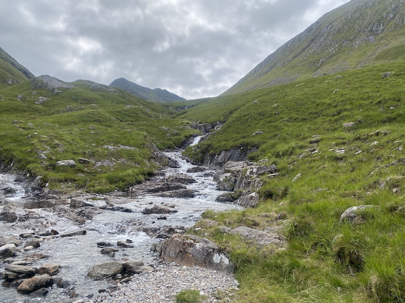
The descent was hard on tired legs but it also provided plenty of lovely views and some beautiful waterfalls. We filled up our water bottles and chatted about how much we had enjoyed the day out. At one point, we spotted a small group of red deer at close proximity.
We had been lucky with the weather and we were both delighted by how well we had coped with the distance, elevation and terrain.
Finally, the road came into sight and we edged closer and closer to the end of our ridge run-hike. But would we get a lift?
Yes, we did! Just two minutes into the walk along the busy road and after putting out our thumbs for the first time, a couple in a campervan pulled over. It turned out that when the driver spotted us he said to his wife that he knew exactly what we had just completed. He had done the route before and he was more than happy to give us a lift.
The man, who is originally from Scotland and now lives with his wife and kids in Norway, was on holiday. We chatted happily about the wonders of Scotland, plus the delights of Norway, while he also gave me some tips on what Nordic skis and boots to buy.
The lift was so much better than the bus would have been – and we thanked the couple for so generously stopping for us.

South Glen Shiel Ridge: The details
Walk/run distance: 27.8km
Elevation: 1998m
Road section: 11km