
I recently qualified as a summer Mountain Leader in the UK. The lead up to the assessment in Scotland felt very stressful and I was anxious about all sorts of things. I would liken the five-day assessment to sitting school exams or university final exams. To help other people feel as prepared as they can be, I’ve compiled a list of tips for being successful in the Mountain Leader assessment.

1 Take the training seriously
The Mountain Leader assessment requires participants to successfully complete a six-day training course. Many trainees see this as a pass or a fail in one area that requires more consolidation. The aim of the training is to prepare people fully to go on to the qualification assessment. It is possible to apply for an “exemption” to the training if, for example, you have have a great deal of prior experience but, for most people, the training will be a necessary part of the process.
Pay attention, take notes, revise everything that has been learned and generally try to absorb all you can from your instructors.
I did my training with Scotch on the Rocks Guiding based in the Cairngorms. The six-day course was highly informative and also enjoyable but there was a lot of learning. I took in as much as I could at the time and then went away and tried to consolidate what I’d been taught.
You will also be given constructive feedback at the end of the training. Don’t ignore this but embrace it and listen to what the trainers are saying.
2 Add your QMDs to the digital log book
To sit your assessment you need to add at least 40 QMDs (Quality Mountain Days) to the Mountain Training DLOG. I already had a wealth of options to add to the logbook but even then it takes time to sift through all the outings and then upload the descriptions, photos and routes etc.
Make sure you learn what a QMD is and if you feel you are lacking in QMDs, you will need time to go out and walk in the mountains.

3 Read and learn
There are lots of resources for further consolidating your learning. The Mountain Training Association (MTA) offers an area of resources and information for trainees.
Make sure you leave enough time to read all the resources and recommended books. Also go though the skills checklist so you cover every aspect of the training in preparation for assessment.
Scotch on the Rocks Guiding also gave me access to their info and resources. These were mostly compiled as short videos.
There are plenty of information videos and articles on-line, too.
I confess I slightly underestimated the work involved in studying all the resources and the checklist before the assessment but I am fortunate that my freelance work and the type of work I do allows me the time and skills to work through this sort of information. I read:
- Hillwalking : The Official Handbook of the Mountain Training Walking Schemes
- Navigation in the Mountains: The Definitive Guide for Hill Walkers, Mountaineers & Leaders
- Hostile Habitats – Scotland’s Mountain Environment: A Hillwalkers’ Guide to Wildlife and the Landscape.
Well, I didn’t read them page to page but I read through as much of the books as I felt I needed to. Some of the information I already knew and understood, while other sections required revision.
All I am saying, is you should allow many hours to do all your research and learning.


4 Go out and practice
I have been walking in the hills and mountains of Scotland for decades and more seriously over the last decade. I can navigate but, like many people, I rely a lot on GPS and phone apps.
The ML assessment requires trainees to navigate by map and compass. You will be tested in poor visibility and the likelihood is this will be in cloud and at night.
It’s vital that you spend as much time as possible navigating by map and compass in a variety of poor weather condtions, and at night, in the run up to your assessment. By all means, use your map apps to work out where you are once you think you have arrived by map and compass but the majority of your navigating should be done only with a map and compass.


5 Use different maps
You may be required to navigate by OS 1:50,000 map, OS 1:25,0000, Harveys 1:40,000 or 1:25,000 maps. Basically, you need to be able to use all map scales. Our assessment focused on OS 1:50,000 and Harveys 1:40,000 but if you are being assessed in England or Wales, a 1:25,000 map may be the more frequent choice.
In any case, learning to map read with different map scales is very useful. Reading the maps is basically the same but you need to familiarise yourself with the scales, the contour lines and features of the maps.
When training, try to use a different map each time.

6 Ask friends to test you
You will need to be able to prove you can micro-navigate. This means pacing on bearing to small features, such as re-entrants, fords, spot heights, contour lines and change in slope gradient etc. I found that the best way to improve my micro navigation skills was to ask friends to set tests for me.
I also practised following friends “blind” as they navigated to different landscape features and then told them where I thought I was. This is called relocating.
I am eternally grateful to two friends in particular, Cath and Rob, who spent many hours in the mountains with me at night-time and in poor conditions so I could practice.
I also booked a refresher day of navigation with James Orpwood Guiding and a night navigation session with Àban.
All of this proved to be vital when it came to the assessment because it refined my skills and boosted my confidence.

7 Learn how to pace distances
Pacing is a vital skill for navigation. You should become familiar with what your step count is for 100m and in different terrains and various gradients.
Practice this over and over until it is almost instinctive. I also used a cord with toggles (from my Flanci skorts) to keep track of each 100m.
You can use timing on a watch/stopwatch as a way to measure distance covered but I found pacing to be far more accurate.
I was still counting paces in my head for at least a fortnight after the assessment because it had become almost subconscious.

8 Slow it down
I am very guilty of marching off at a speedy pace but this is no good if you want to navigate and it’s also not helpful if you are guiding a group.
I have learned to be aware of the pace of other people and to slow my speed accordingly to ensure they are comfortable.
It also makes it easier to navigate when you walk more slowly because you have the chance to look around at the detail of the terrain.

9 Swot up on flora, fauna, geology, history and culture
The mountain leader assessment is not “just” about navigation because the aim as a leader is to offer people an all-round experience. You should be able to tell them plenty of details about the place where you are walking.
Knowing a few bits and pieces about flora, fauna, geology, history and culture will be interesting for clients and it also allows for natural stops and breathers when walking in a group.
I have picked up lots of details over the years by reading and listening to other people. But if you want a lesson, have a flick through Hostile Habitats and store away some fascinating facts to reveal on the assessment.

10 Get relaxed with wild camping
The assessment requires a three-day exped and two nights of wild camping. Make sure you have practised and you do not look like you are uncomfortable with the concept. It’s a good idea to check the kit list and do a few of your own overnights before the assessment.
Ensure you can carry a fairly heavy pack for three days in the mountains and, of particular importance, is your ability to pitch your tent, stay warm and cook a warming meal.

11 Learn the ropes
The assessment includes other skills such as rope work, river crossings, route planning, first aid, what to do in an emergency, your leadership ethos and more. This is all detailed in the training and resources and it is vital you have a clear idea of the procedures.

12 Speak to others about their assessment
No ML assessment will be the same but there are similar routines and it can be really useful to speak to a friend who has completed their assessment. Ask them lots of questions and find out what they found difficult.
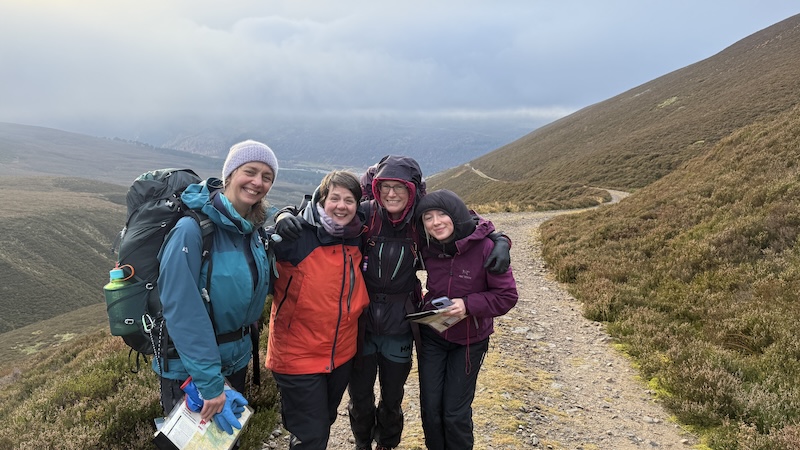
13 Bond with others
I was very fortunate that my assessment group with Scotch on the Rocks comprised four women and four men and we decided to split into gender groups. The support of three other women was invaluable, especially in terms of boosted confidence and general support.
We enjoyed each other’s company and had a fun adventure as well as facing the stress of being assessed.
14 You will be watched and analysed but feedback is scant
The assessment is daunting because you do not know until the end if you have passed, or if you will need to resit aspects. Few people have outright fails but they may need to return for a day to be reassessed.
The instructors want you to pass so they are not trying to catch you out but they must ensure you reach the right standards for taking people into the mountains on your own.
The part I found the most difficult was the “poker face” of the instructors. When we were doing our navigation legs, it was impossible to know if you had it right or wrong because they gave no clue as to their emotions. This is something I am unfamiliar with because mostly you can read someone’s face to know if you have got something right or wrong.

15 Buy a good quality headtorch
The night navigation is tough enough so make sure you have a good quality headtorch with decent lumens output. Take a spare battery, too, because you could be out for many hours and you do to want the torch to fail.
I used the Silva Free 1200 XS head torch and it worked really well.

16 Finally, believe in yourself
I am not a naturally confident person. Unfortunately, I have never been able to forget that an ex-partner told me I was “navigationally challenged”. I think he was cruel in what he said and could have supported me to learn, so it took me many years before I even tried myself.
I have learned to navigate and I now believe I am proficient. My ML certification proves this. But I think I learn in a different way to, for example, many men.
I found a women-only navigation course to be extremely useful. I have also been fortunate with my husband and friends who are very happy to discuss navigation, rather than take over and lead.
It has probably taken me longer to learn to navigate safely in the mountains but I now know I am very capable and I should believe in myself and my abilities.
I hope this post has helped. If you would like to learn more, please do get in touch.
What’s next now I am a qualified mountain leader?
I will be setting up a new branch of my business with the aim of offering navigation courses and mountain leader trips and adventures in Scotland. If anyone is interested, please do contact or message me the sort of trips you would most like to do.