Already famous for skiing and snowboarding in winter, Chamonix in the French Alps is seeing a huge surge in trail runners in the summer. Thanks in part to a growing ultra running scene across Europe and also due to increasingly popular races, such as the UTMB (Ultra Tour du Mont Blanc) and the Marathon du Mont Blanc, many more runners are booking holidays to Chamonix and the surrounding area simply to run.
This destination had been on my must-do radar for a while and recently I took the opportunity to extend a trip to Verbier, Switzerland, with a stay in the outdoors town of Chamonix and the nearby village of Argentière.
I discovered for myself an amazing array of mountain trails that are perfect for running. Many of these routes have long been established as hiking paths and they are often well sign posted.
How to find out about trails
A great resource for trail information is Chamonix360.com, which has been created by hiking and running enthusiasts in Chamonix. This website provides a comprehensive overview of the best hiking and trail running routes around Chamonix, including detailed maps, trails descriptions, points of interests, GPX files and 3D fly-throughs. They also have a YouTube channel featuring short fun videos and showcasing the most popular trails around the Chamonix valley.
Other places to discover an array of trails is the dedicated La Vallee du Trail leaflet and website.
There are also plenty of guides who will show you the trails and happy you to train for races in the Alps.
Here are a few trails that I ran while in the Chamonix valley, as well as others to try.
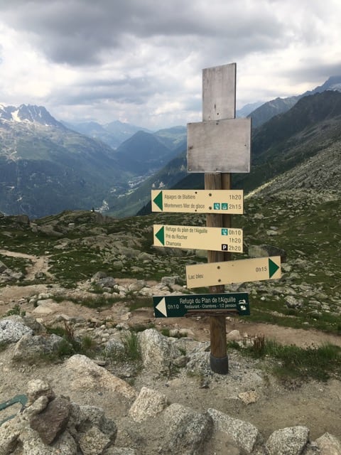
Many trails are signposted.
The Petit Balcons, Chamonix
The Chamonix Balcon routes include “petit” and “grand”, all of which are great for running (and walking). They comprise beautiful panoramic routes with an almost constant level of altitude and can be done partially or entirely.
The Petit Balcons run around the lower valley floor at an approximate altitude of 1200m. There is a “Nord” (north)Petit Balcon and a “Sud” (south)Petit Balcon.
The Petit Balcon Nord runs from Argentiere to Les Bois, on the north side of the valley and is around 200m above the valley floor. You can start the trail at the entrance to the Grand Montets car park in Argentiere and follow the route back down the valley to Les Bois before continuing on to Chamonix.
The Petit Balcon Sud is the longer of the balcon trails and starts in Argentiere at the bridge by entrance to the Grand Montets car park. It follows a route to Servoz (recommended direction). It has a fairly steady altitude of around 1250m and is mostly in the forest.
See more info about the Petit Balcons.

I enjoyed running solo on the signposted trails.
The Grand Balcons in Chamonix


The Grand Balcon Nord
From Plan de l’Aiguille to Montenvers (Route 1).
It runs along the north side of the valley. Both the access and departure points are served by lifts. The start is at the Top of the Aiguille du Midi cable car station and the finish is at the Mer du Glace Montenvers mountain train.
I greatly enjoyed this route and chose to run the descent from Montenvers rather than catch the train. It was a fairly brutal run downhill of about 900m but the views were more than just rewards.


A path across the mountains in the French Alps.
From the top of the cable car station, the signposted route descends to the Refuge du Plan de l’Aiguille and then follows a path going off horizontally to the right to La Tapia (not to Chamonix via Plan du Trois or Pre du Rocher).
It’s easy to see the path ahead and regular signposts prevent you from making a wrong turn. I was wowed by the vistas of high peaks and the valley far below.
After the sign to the Chalets du Blaitière (continue straight on), the next junction offers a choice of route. To the left is a shorter but very narrow path that leads to Montenvers across steep gullies (I took this and, at times, properly frightened myself. So much so that I walked quite bit rather than running. I was worried I would trip and fall over the edge.)


The better route to take (I discovered this later) is the path that climbs up to the right to the Signal Forbes (2198m). Once at the top, the path continues down to the Montenvers’ viewpoint and the railway station.
The Grand Balcon Nord
From Croix de Lognan to Le Lavancher (Route 2).
Start by taking the Grand Montets cable car up to the Croix de Lognan and then follow the path on the right below the Bochard gondola and Marmottons chair lift.
At the Chalet de Plan Joran (closed in summer) continue straight on past the base of the Plan Rougon chairlift and follow the path into a larch forest. When the route descends into a meadow beside the Chalets de la Pendant, you’ll enjoy views of the Brevent and the Aiguilles Rouges.
Follow a path further downhill. There is an option for a bit of uphill following the route to le Chapeau via the Tête des Prapators, which re-joins the main route further down and eventually brings you out at Le Lavancher.
Return to Chamonix by bus from the main road (RN 205), a short distance below Le Lavancher.
The Grand Balcon Sud
From the Col des Montets, beyond Argentiere, down to Les Houches.
This is popular run and starts as you exit the top station of the Flegere cable car. Drop down to a path that leads off horizontally to the right from the small Refuge de la Flegere.
As you cross a scree slope, you can see the route ahead as far as the Alpage de la Charlanon (the cable car between Charlanon and Flegere that is only open in winter).
Once across the meadow, you’ll reach the bottom of the Charlanon ridge and then a small wood that takes you above the Parsa Combe (Col Cornu chairlift).
The path continues up to the Planpraz plateau from where you will see the cable car and gondola stations below you. Doing the route in this direction gives you the best views of Mont Blanc and the Aiguilles de Chamonix.
See more info about the Grand Balcons.
Argentiere to Refuge Lognan run

While staying in Argentiere at The Dahu Hotel (well priced, clean, comfortable and great breakfasts) I took advantage of the nearby Grand Montets cable car for another brilliant running route. See Argentiere to Refuge Lognan run.
Running the Tour du Mont Blanc first stage

I enjoyed a fantastic day or running with Run the Wild, form Chamonix to Les Contamines. It is the first stage of the UTMB and totalled around 17 miles. Read about my trail running day with Run the Wild.
Mont Blanc Vertical Kilometre from Chamonix
This is one for a future trip but many people do the vertical KM as a race, or simply for a challenging run.
Chamonix’s vertical km is 1000 metres over 3.8km. It starts in the centre of Chamonix and follows a steep, zigzag route up the side of the mountain under the Brevent chair lift.
Other things to do in Chamonix in summer
There are plenty of options for days when you don’t fancy running or walking.
- How about the via ferrata des évettes?
- Rafting or paragliding with Compagnie des Guides
- Cham’Adventure offers canyoning and other outdoor activities in summer.
- There are plenty of mountain biking trails, too, and bike hire outlets.
There is a wealth of information about activities on the Chamonix website and also a smartphone app.