
Discover an adventure to bike and hike the Corbett, Beinn Dronaig in Wester Ross. The article was published in the Scots Magazine.

Bike and hike of Beinn Dronaig
The walk to the summit of Beinn Dronaig is relatively short but the route to reach the mountain in Wester Ross, north-west Scotland, is long and lumpy.
Even after careful planning and consideration, the eight-mile track from Attadale Gardens, just off the A890 single-track road, took my friend Rachel and I by surprise.
Given that it was late winter and the days were still short of daylight, we decided to use mountain bikes for the first section of the adventure.
We also tied in with the train service from Inverness to Attadale – a request stop – on the Kyle of Lochalsh Line. The first train arrives at 10.50am so there was no time to waste.
From the remote station, we pedalled off at speed on a short section of tarmac road to the entrance of Attadale, carrying rucksacks ladened with winter outdoors kit, including crampons, ice axes and walking poles.
The beautiful gardens are open to the public and I made a note to revisit for a wander around another time.
Skirting the southern edge of the gardens, Rachel and I then turned to the south-east and continued on the wide track, following the same route of River Attadale.
A mile or so of easy cycling came to an abrupt end after we crossed a footbridge south and over the river. The first of many steep uphills during the next seven miles was eased slightly by tight zig-zags but we were still forced into our easiest gears to continue the climb.
The track levelled for a short while before continuing a more gentle, but still muscle-challenging, ascent over many smaller ups and downs to reach an elevation of some 650ft.
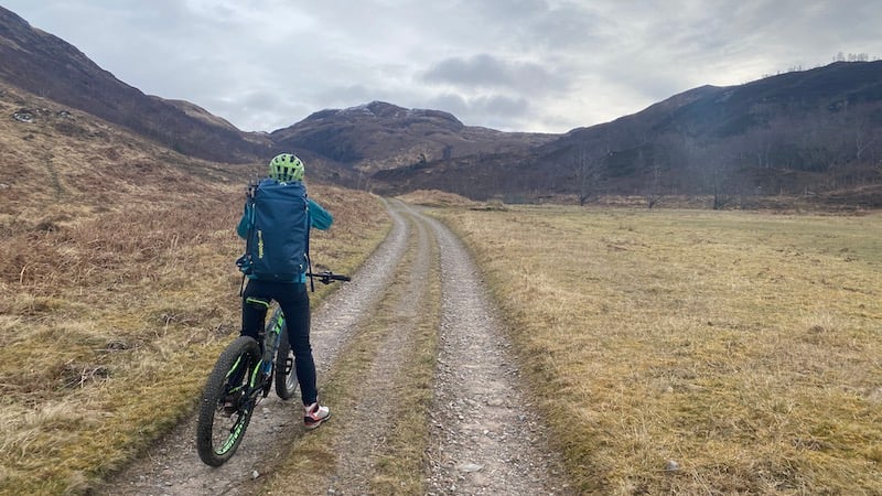
We stopped a couple of times to catch our breath and look behind at the superb views over Loch Carron and across to the Applecross mountains in the distance.
At tiny Loch an Droighinn, our route swung north-easterly and although we were still riding uphill, Rachel and I were convinced we had completed the toughest sections. Sadly, the steepest gradient was still to come and it was simply hidden around the next corner, just past Loch na Caillich.
I confess I didn’t manage to stay on my bike despite trying very hard to grind the pedals round and round. As well as being a testing incline, the track had become much rougher with loose rocks and stones to negotiate.
I could only watch as Rachel, who is a more skilful mountain biker, continued to ride while I was forced to get off to push my bike the final 80ft.


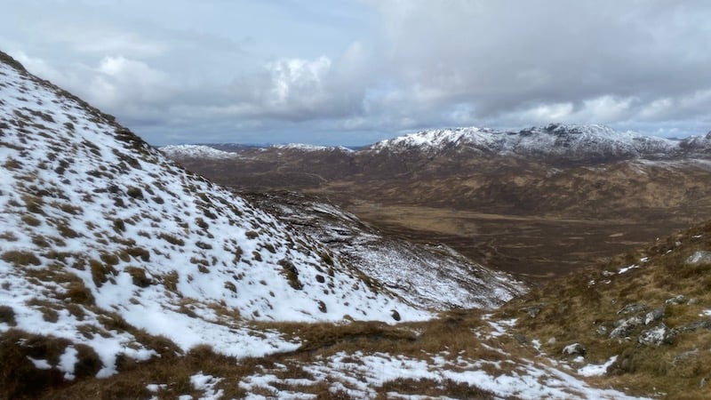
Back in the saddle, we enjoyed an easier upwards slope until we reached 1100ft above sea level. The reward for our morning’s efforts came with a fabulous vista of many remote mountains spread out to the north-east, including our target, Beinn Dronaig. They were all capped in picturesque snow.
From here, the track began to descend and swiftly we cruised to a height of 650ft. Losing so much height so quickly would normally be spirit-lifting but Rachel and I realised this would mean we had a greater height to climb on foot.
We passed Bendronaig Lodge, just to our north, which serves as a bothy for passing walkers and cyclists. The lodge is maintained by Attadale Estate and while offering basic living and sleeping accommodation, it has the bonus of a remote toilet.

Hike to summit of Beinn Dronaig
Soon after, we spotted the start of our walking route of Beinn Dronaig, which at 2614ft tall qualifies as one of the 222 Corbetts in Scotland.
Swapping from cycling kit to walking clothes and boots, we locked out bikes together and started out on foot, heading east away from the track. The ground was immediately wet and boggy and we spent some time trying to jump between raised grassy tussocks before giving in to a generally squelchy hike towards the shoulder of a high crag.
Back again at 1100ft elevation, we joined a narrow and craggy path south, which rose in steps until we suddenly encountered snow 200ft higher up. Without an obvious path, Rachel and I decided that a generally southerly approach uphill made sense.

We were grateful for our crampons and ice axes on the slippery ground, and especially when the snow became deeper.
Every so often, we stopped to take in tremendous views of numerous mountains, including the recognisable peaks of Torridon.
The summit finally came after turning east at around 2400ft elevation and then homing in on a trig pillar. This is a mountain to reserve for a clear sky because of the wide-sweeping panorama, including Loch Monar to the east, the Mullardoch and Strathfarrar mountains and west to the Isle of Skye and the rugged ridge of the Cuillin.
The plan was to return by the same route and although this can sometimes feel like a less exciting choice than a circuit, I was looking forward to the views in reverse.
The descent from Beinn Dronaig was straightforward simply because we could follow our snowy footsteps. We were cautious at icy sections and on steep rocky but in seemingly little time, we found ourselves below the snow line and back on the boggy lower slopes.

Bike back to the start
Swapping walking kit for cycling clothes, we hopped back on our bikes and started with a delightful ride downhill. We both grinned as we zipped along on the rough track that had seemed so much more daunting on the climb up.
Passing the lodge again and then rounding a corner and over a bridge, we were presented with the first section of uphill. It was a long ascent on tired legs and we were forced to drop the gears and settle into a slow climb.
And then came the final and joyful downhill section. This was what we had been looking forward to and it didn’t disappoint.
The flatter track around the garden estate, took us back towards Attadale station and any worries that we might not make the limited service were alleviated as we realised we had more than an hour to wait for the 5:49pm train.
Fact: Beinn Dronaig takes its name from the Gaelic word “droning”, which means “humped”., or a mountain of little height. This is a modest name for the Corbett of most than 2600ft height.
Bike and hike: The route & where to stay
Start and finish: Attadale, West Ross.
Distance: 20 miles (30km)
Total ascent: 4500ft (1370m)
Extend the trip: Enjoy a couple of nights, before and after the bike and hike, at Strathcarron Railway Cottages. Strathcarron is the train station before Attadale on the Kyle of Lochalsh Line.
Tip tip: Ensure you book a bicycle reservation on the train because there are limited spaces.

Kit list: Beinn Dronaig
- Mountain bike
- Large walking rucksack
- Cycling clothes
- Bike helmet
- Gloves
- Footwear – cycling shoes and walking boots
- Walking clothes
- Waterproof jacket and trousers
- Spake layers
- Spare hat and gloves
- Walking poles
- Ice axe
- Crampons
- Emergency bivvy bag
- Map and compass
- Mobile phone
- Food and water.