I have completed a circuit of the Strathfarrar Munros in the Scottish Highlands several times. On this occasion, I completed it entirely on foot and did not rely on a bike for the track along the glen. I also went in a clockwise direction.
Planning ahead for the Strathfarrar Munros
The first thing to do when planning this adventure is to check out the Strathfarrar access at Milton Cottage near Struy. If you want to access the glen by vehicle, you need to follow the rules. It doesn’t cost anything for access but this is granted to only 25 vehicles per day and you need to exit on the day you enter.
- Summer opening times are daily 9am to 6pm in April; 9am to 7pm in May; 9am to 8pm in June, July and August; 9am to 7pm in September and 9am to 6pm in October.
Winter access is by arrangement via Mountaineering Scotland.
If you are on foot or bicycle, access is anytime all-year-round.

Having checked the schedule, Cath I I joined the queue of vehicles on a Sunday in April just before 9am. We were checked in through a locked gate by the gatekeeper and then drove from Milton Cottage some 19km west along the glen track, before parking.
If you want to use a bicycle for the start or finish section of this circuit, you could drop a bike where we parked and then drive back to a parking area near a power station, or leave a bicycle near the power station and park further along the glen. The route along the track is fairly flat so it doesn’t really matter which way you plan to go. You should be sensible about where you park.
Four Munros and two Munro Tops
Readers of this website – and my friends – will know that I am keen to bag Munro Tops, as well as Munros these days. I have already completed a round of Munros and while I am very happy to do Munro repeats, I do like to tag on a Munro Top where possible.
This circuit of the four Munros, Sgurr Fhuar-thuill, Sgùrr a’ Choire Ghlais, Carn nan Gobhar and Sgurr na Ruaidhe, also includes two Munro Tops, Sgurr na Fearstaig and Creag Ghorm a’ Bhealaich. The new summit for me was Sgurr na Fearstaig.


On foot to the first Munro Top and Munro
Having parked the car, we headed northwards on foot and on a very obvious and wide track. The track turns into a well-trodden path that climbs up to the wide ridge of Munros. The going is steep at times but Cath and I are good at taking wee breathers and then pushing on.
The narrow path to the first Munro Sgurr Fhuar-thuill traverses and climbs at a fairly gentle gradient below the 1049m summit but my Munro Top Sgurr na Fearstaig was located to the west and long the ridge, so we decided to ascend on rough vegetation in a more direct route. You could go up to the Munro and track back along the ridge to the MT but this adds extra distance and time.
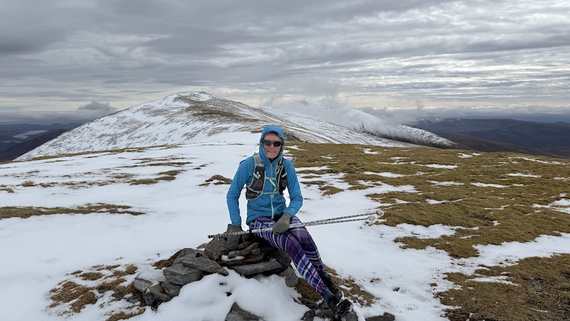
After a particularly steep but short ascent, we gained the ridge and the gradient lessened before we reached a cairn at 1015m to mark the MT.
There was an obvious trod heading east and we could easily see the first Munro, some 500m or so ahead. There was a short, steep descent and then a gentler ascent to reach another cairn atop Sgurr Fhuar-thuill.
While we had been enjoying some warm and sunny early summer weather, a dump of snow mid-week meant that the ground at higher elevation was covered in a thick blanket of the white stuff.
Cath and I had planned to run as much of this mountain route as possible but the snow meant we needed to hike more than expected.
We met a few other hikers coming in the opposite direction and a couple of the said they had chosen to do an anti-clockwise route because of the wind direction. We felt the wind was more southerly than easterly so we remained happy with our choice of direction.


Munro Top 2 and another 3 Munros
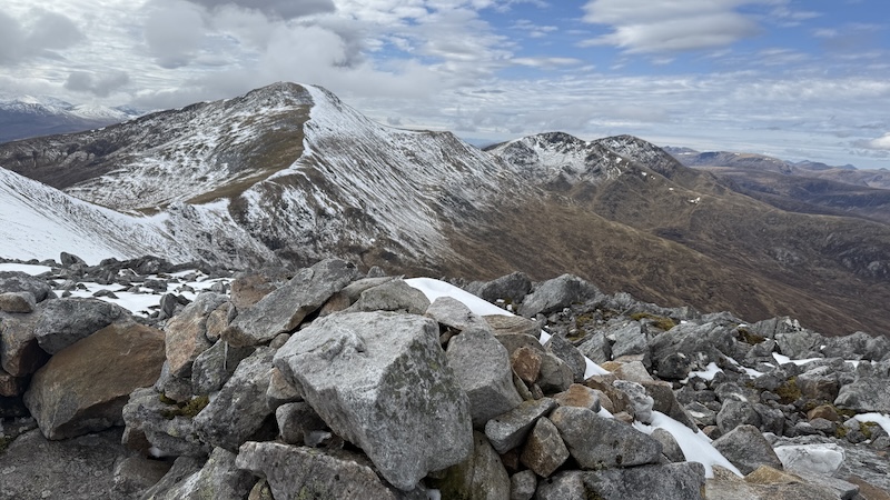
The next summit is another Munro Top, Creag Ghorm a’ Bhealaich at 1030m height. Again there is a cairn and it would be easy to imagine you have reached Munro number two already but that was further along the ridge.
Another 1.5km of snowy hiking took us to Sgùrr a’ Choire Ghlais at 1083m elevation and the highest point on our route. The views along the entire ridge are superb and especially from this summit.
The next Munro, Carn nan Gobhar seemed to arrive quite quickly and at 992m elevation, it is the smallest Munro on the ridge.
We found ourselves in cloud on this summit and made a short error, descending off the wrong side (NW) but we quickly corrected our decision and headed east, then south and then south-easterly towards the final Munro, Sgurr na Ruaidhe with a height of 993m.


I was surprised by how quickly we reached this line of Munros. The next stage was a long descent south to regain the track in the lower glen.
A run back along the glen
Here we met a few other walkers who had parked just off the track and they offered us a lift back to our vehicle. But Cath wouldn’t hear of it. She is training for the Skye Ultra and she said she needed the extra kilometres of training.
By now, the sun was quite strong and the glen felt very warm. We set off at a jog along the track and after a while we both settled into our own paces. I am a bit faster along a flat track compared to Cath but she told me at the end that she was encouraged to run the entire 7kms, rather than walk parts of it, because she could see me ahead.
The circuit forms a superb route with great views. In good weather, route-finding is fairly straightforward thanks to plenty of tracks and trods.

Route details: Starthfarrar Munros and MTs
Distance: 25.5km
Total elevation: 1650m