
I was on a Munro bagging mission this weekend. After a fabulous day on the Ring of Steall in Lochaber I also wanted to hike Carn Mor Dearg, “just along” Glen Nevis. It was a Munro that I had set out to summit in February with the Munro blagger (aka Bobby) but we had been turned back by deep snow.
The Munro, more fondly known as CMD, is a neighbour of the mighty Ben Nevis and linked by a famous arête. Many people are keen to hike CMD and then walk the arête (narrow ridge) to reach the top of Ben Nevis. I had hoped to do this but the weather wasn’t promising early in the day and by the time the clouds had started to lift I was a bit short of time.

Cloud hung in the valley early on.
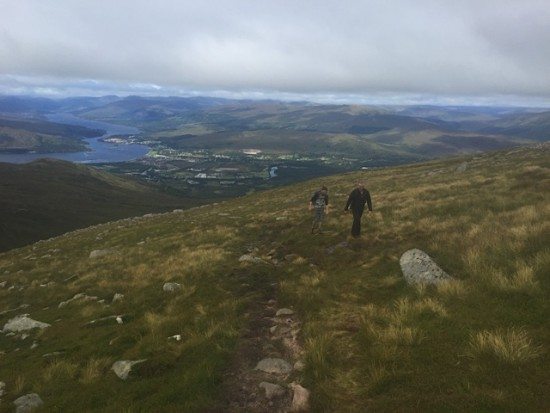
But it started to clear as the morning went on.
Instead, I set off in fairly good conditions to hike only the CMD. And I was so pleased that I decided to do so because the mix of clouds, mist and bright sunshine offered some truly incredible views.
The hike was going to be solo. The Deeside walkers had plans to do other mountains in the area and the G-Force had arranged for a climbing day with his pal M. I carefully assessed the conditions and the route, armed myself with the OS map, Walk Highlands notes, compass and also a route downloaded on to a View Ranger app on my phone.
I was confident I’d manage the outing myself and if the clouds became too dense I would simply turn back.
Then, while driving towards the North Face car park from Fort William I had a message to say that M wasn’t feeling too well (self-induced hangover) and they had decided to walk with me rather than climb. I was pleased but I still planned to lead the route.
Route finding on CMD
There are several ways to approach CMD. The first is via Glen Nevis, which is the route Bobby and I attempted in February. Another way is to summit Ben Nevis then walk the arête to the summit of CMD. A third possibility is to leave the North face car park and approach the summit in a southerly direction.
With limited time and the worries about cloud cover I chose the easiest looking route from the North Face car park.
At the outset I knew there would be a good path through the forest and then a well-trodden route along the start of the glen. From here, the Walk Highlands description revealed a boggy path up the north-west flanks of Carn Beag Dearg.

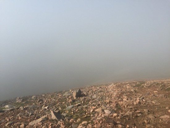
I walked into cloud…
And then popped up into sunshine again as I walked higher.
On the map, it looked as though this path gave way to rough terrain and so I had my compass and map all set to follow a bearing first towards the summit of Carn Dearg Meadhonach and then to CMD summit proper.
I was actually quite disappointed when I discovered that the path is almost non-stop from the car park to Carn Dearg Meadhonach and very easy to find. The only slightly difficult section was when walking up the side of a burn. It could be easy to overlook a path on the opposite side of the burn but with a bit of clever sighting most people will be able to spot the muddy trail.
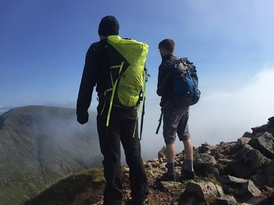
The clouds still hung fairly low in the glen as we made our way upwards. The G-Force and Martin stopped frequently to point out climbing routes on Ben Nevis that they had climbed or wanted to climb. I became a bit bored by their climbing chat and headed off and uphill at a faster pace.
I was enjoying the challenge of navigating myself. Half way up the mountain I headed into the clouds and I imagined that I’d be walking in mist for the rest of the outing. But not so.
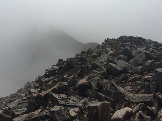

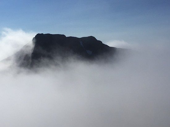
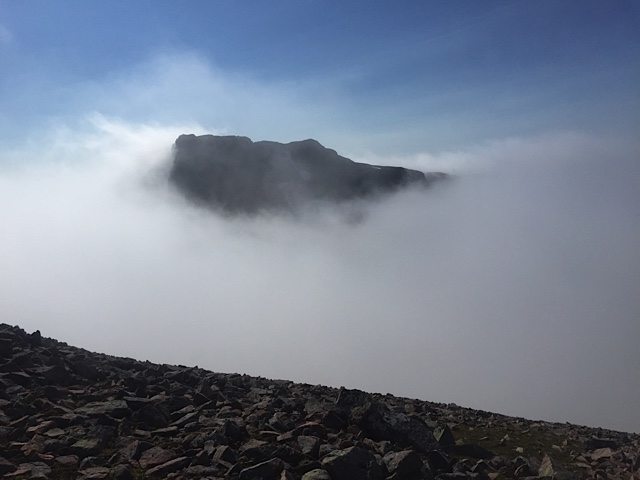
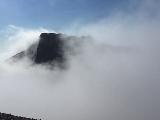
Amazingly, some 200m from the top I popped up into sunshine and blue skies. It was an “almost” inversion and as I walked I cold see the top of Carn Dearg Meadhonach clearly to my left and, occasionally, the top of Ben Nevis to my right.
I almost whooped for joy because I knew from previous experience that we were likely to be treated to some amazing above-the-cloud views.
At Carn Dearg Meadhonach, it would be easy to think you had reach the summit of CMD. But I checked the map and then my iPhone GPS app and realised this wasn’t the Munro top.
I took a bearing from Carn Dearg Meadhonach to CMD and worked out we needed to head SSE for another 500m and with 40m of ascent. We couldn’t see the pointy top of CMD at this point but as the sun shone harder the clouds broke and we saw our highest point ahead.

For the following hour or more we oohed and ahhed at some of the best views I have ever seen on Scotland’s mountains. Every few minutes the clouds would break and we were treated to superbly clear views down different glens and across to the Ben itself.
We even had the start of a Brocken Spectre.
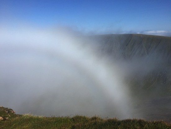

I think we were lucky with the weather. The views would have been impressive on a bright and clear day but I think there were even more magnificent in the clouds. See what you think.
The descent was painful on tired legs and I was glad when we reached the glen floor path again. The path home always seems far further than the path out, especially when you have summited five Munros in two days.

Looking back up the valley to the bealach between CMD and Ben Nevis.
My total is now 192 Munros, which leaves me 90 to compleat a round!